Click here for information and updates on the work of the Megunticook River Advisory Committee
On this page you will find:
1) Information on how the Town manages dams and water levels on Megunticook Lake and River.
2) Links to information on the work of the Megunticook River Citizens Advisory Committee.
3) Information on the $1.6 million Coastal Resiliency grant awarded to the Town of Camden by the National Fish and Wildlife Foundation and NOAA.
4) Information on studies commissioned by the Town of Camden on the management of the Megunticook River and dams, including:
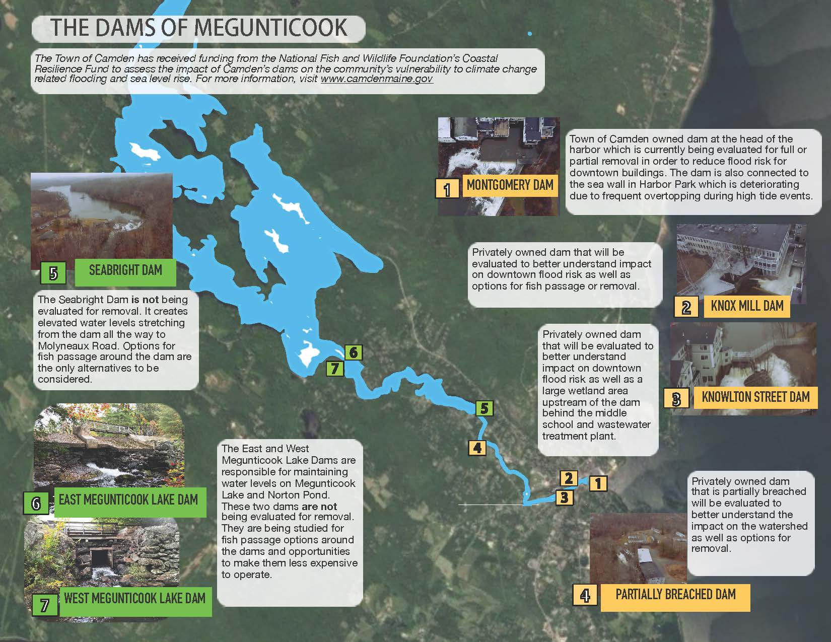
- The Montgomery Dam Feasibility Study
- The Megunticook River Feasibility Study (First NFWF Coastal Resiliency Grant)
- The Montgomery Dam Close Out Report (First NFWF Coastal Resiliency Grant)
5) Basic facts on why the Town is studying options for how we manage the Megunticook Lake/River into the future.
If you are you interested in daily updates about Megunticook Lake levels and how the Town manages the dams, please click here.
Click here to view the Megunticook Lake Level Logbooks.
Updated pages (10/23 to 5/23).
On August 29th 2022, the Town of Camden was awarded $1.6 million by the National Fish and Wildlife Foundation and National Oceanic and Atmospheric Administration through the National Coastal Resiliency Fund.
Signed NFWF Grant Agreement.
Please click here for a copy of the full grant narrative.
The grant will fund community engagement and coordination with public and private property owners to complete a review of conceptual design options followed by design and engineering for the 4 lower dams and associated structures in their impoundments and design for fish passage options for the 3 upper dams.
As part of funding provided through the National Coastal Resilience Fund, the Town of Camden recently completed a feasibility study for increasing the resilience and habitat potential for the Megunticook River Watershed. To read the entire Megunticook River Restoration Feasibility Study please click here.
The overall goal of the assessment was the following:
- Identify and implement river management options for the Megunticook River that improve flood and community resilience, restore habitat connectivity and ecosystem health, reduce infrastructure management needs, and enrich community values and experiences through enhanced public access and use, educational value, acknowledgement of Town history, and landscape aesthetics.
In response to this goal, specific Objectives include:
- Reduce impacts to flood levels and enhance natural buffering of runoff by managing (remove or modify) no longer used dams and other infrastructure.
- Maintain water levels in Megunticook Lake and the Seabright impoundment according to current established patterns, where it is critical for property values and recreational use.
- Reduce the operation requirements of Town staff and private forces to manage the dams to limit flooding impacts.
- Reduce the Town and private resources required to maintain and repair aging infrastructure and manage risk.
- Enhance resilience to climate change by eliminating unused structures from the river corridor to maximize space for future floods and natural stormwater buffering.
- Avoid or mitigate impacts to infrastructure and buildings that will remain along the river corridor.
- Restore safe, timely, and effective passage potential for native sea-run and resident fish.
- Restore river connectivity to benefit fish and wildlife, water quality and ecological processes.
- Enhance public access and use of the river corridor by facilitating educational opportunities and interface with other access Initiatives such as the Camden Riverwalk.
- Enhance the acknowledgement of the historical role of the river in Town history through research, interpretation and dissemination of knowledge.
- Enhance the community landscape aesthetic through integration of the restored natural river corridor with the surrounding built environment.
Project Background:
In 2018, facing costly repairs to the Montgomery Dam, a feasibility study was done to better understand the options moving forward. It was found that the dam significantly increases flood risk in portions of the downtown area while also creating the first in a series of fish passage barriers to species including alewives, blueback herring, sea-run brook trout, and American eel. The study also found that dam removal would provide the lowest cost option to the Town over the next 50 years and be the most likely to receive outside funding from environmental organizations and state and federal agencies due to increased flood protection and access to habitat.
In 2019, the Town of Camden received a municipal planning and technical assistance grant from the Maine Coastal Program for engineering and design for full or partial removal of the Montgomery Dam as well as reconfiguration of the connected seawall. The purpose of the grant is to do the design and engineering work needed for an option that would allow both the Megunticook River and Harbor Park to be better prepared for climate change with less of a need for ongoing maintenance.
Any decisions about whether to move forward with construction plans will require multiple levels of approval from the Select Board, the Library Board of Trustees, and finally Town voters. No decision has been made and your input will help us determine the next steps in the process. At this point, we know that the dam and seawall require significant investment and that doing nothing is not an option. Significant grant funding is available for projects that restore habitat, reduce storm risk, and implement nature based solutions that require little to no maintenance.
We will look for opportunities to benefit adjacent properties and businesses through the design and will discuss how specific and shared goals might correspond with ecological restoration, tourism, recreation, connectivity to the working waterfront and sources of potential grant funding. 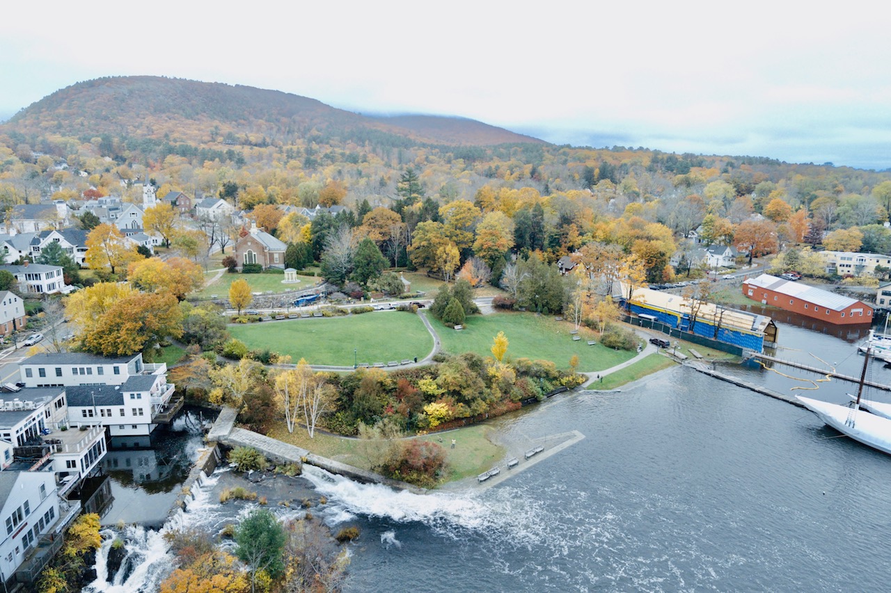
This work is part of the town’s ongoing effort to increase community resilience to climate change and restore and protect important wildlife habitat.
The NCRF restores, increases and strengthens natural infrastructure to protect coastal communities while also enhancing habitats for fish and wildlife. Established in 2018, the NCRF invests in conservation projects that restore or expand natural features such as coastal marshes and wetlands, dune and beach systems, oyster and coral reefs, forests, coastal rivers and floodplains, and barrier islands that minimize the impacts of storms and other naturally occurring events on nearby communities.
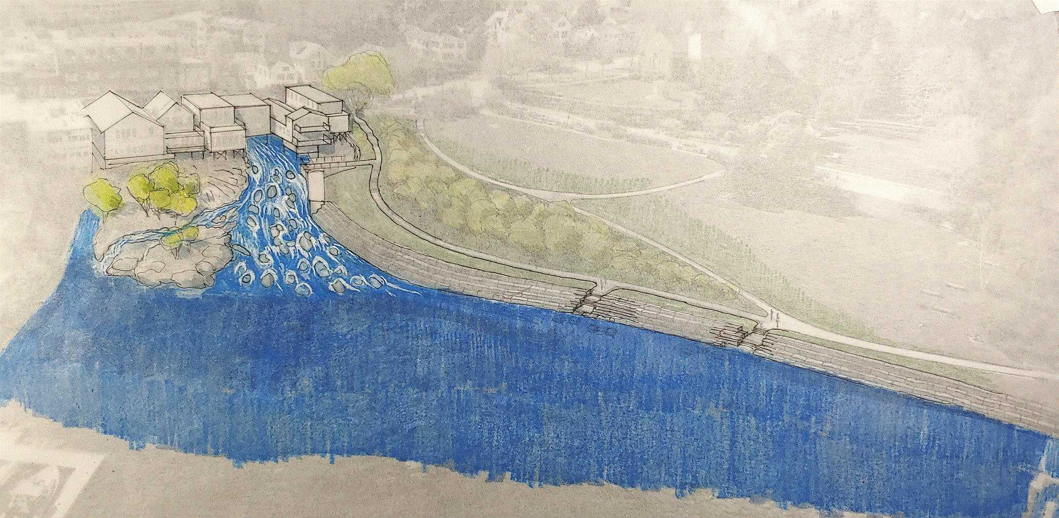
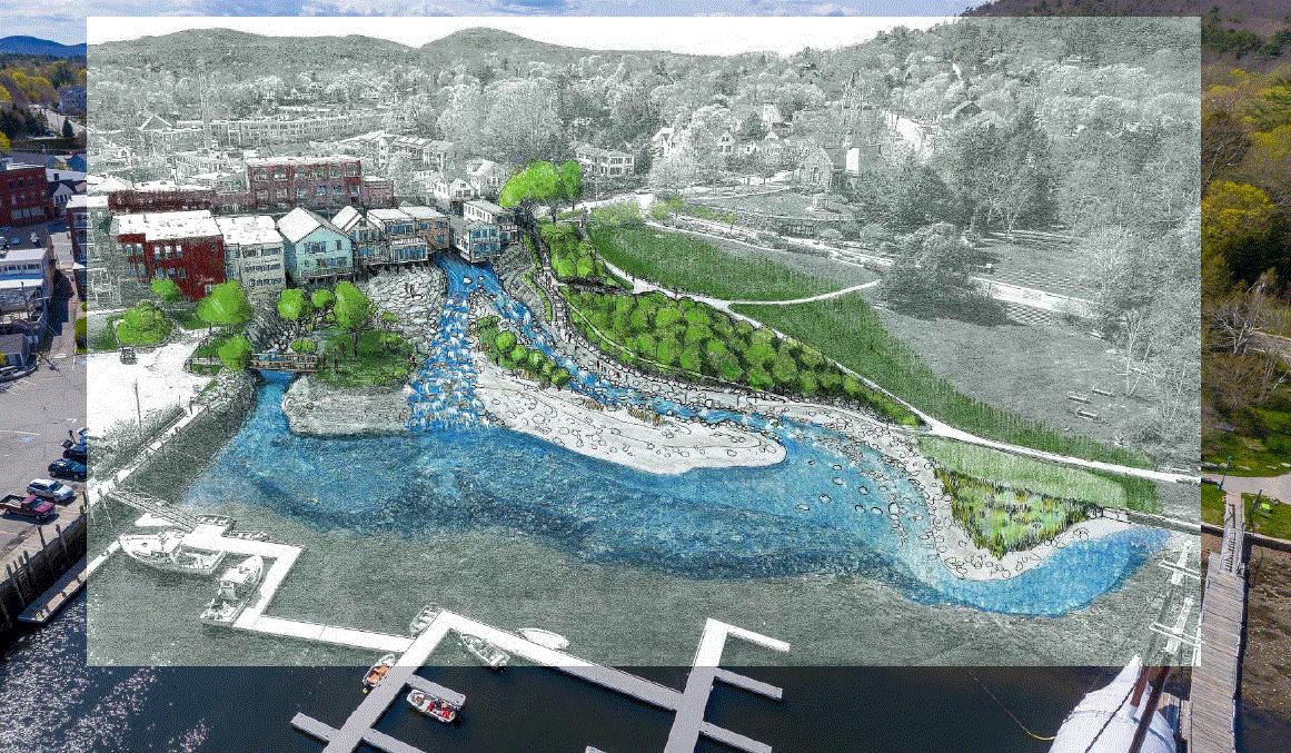
Concept designs for the partial removal of the Montgomery Dam with a stepped seawall:

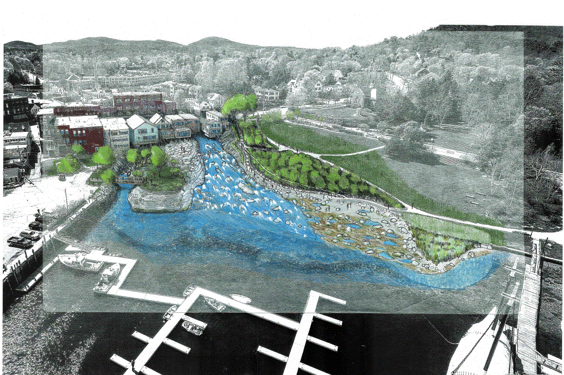
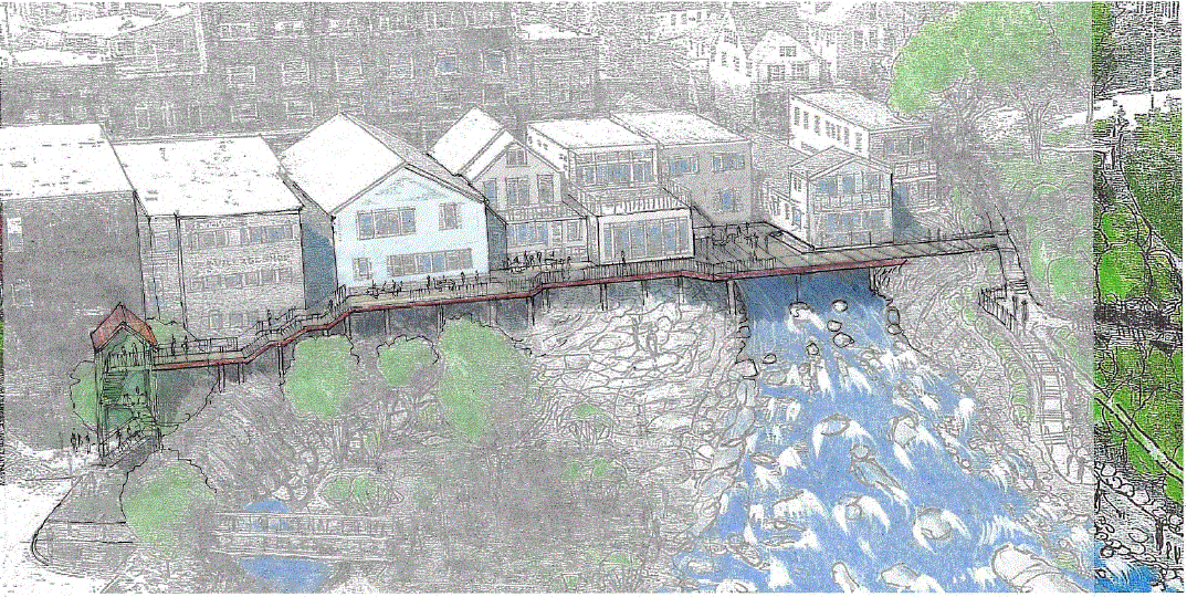
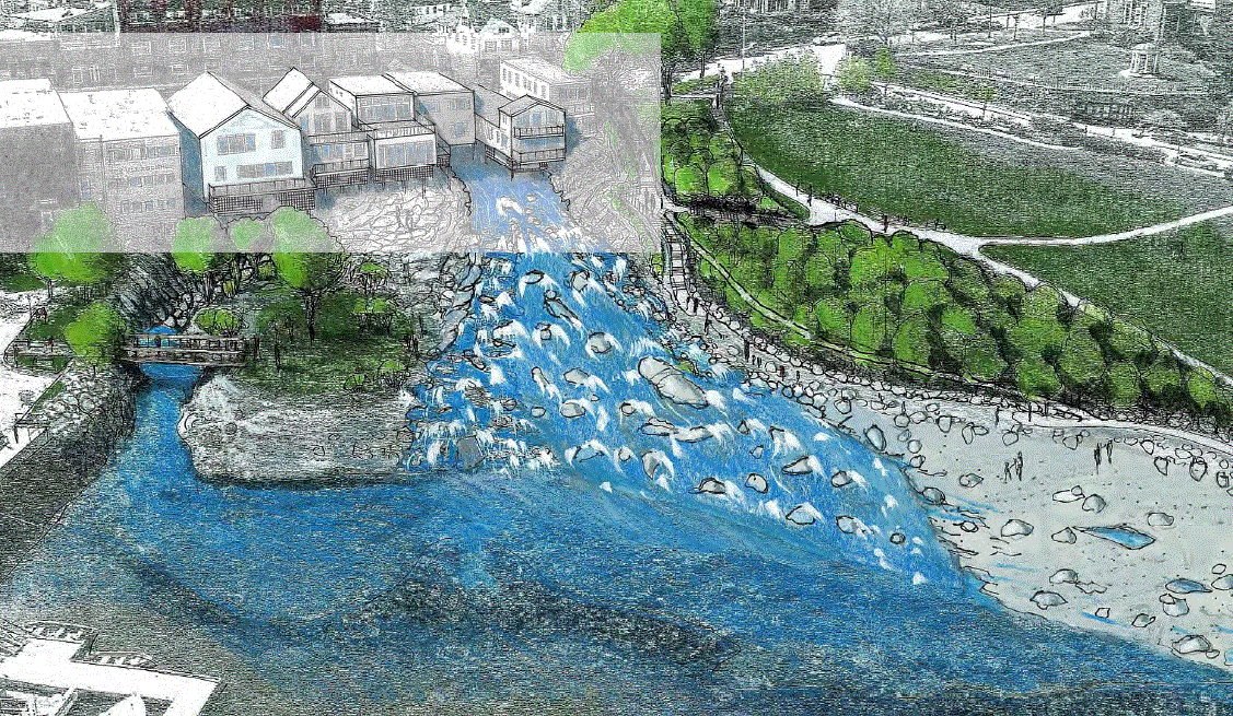
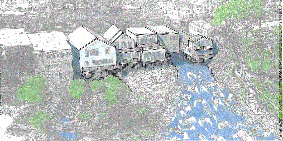
Concept designs for removing the Montgomery Dam and restoring the natural river channel:
Frequently Asked Questions About the Montgomery Dam Project:
Q1: Does the Montgomery Dam pose a flood risk to the Town?
A1: The Dam increases flood risks by trapping water in the impoundment and raising the water level as opposed to allowing this water to flow into the Harbor. While the Town tries to manage this risk by opening the gate before rain events, there are circumstances when we cannot let out enough water to accommodate the amount of rain, or we receive much more precipitation than was anticipated.
This video illustrates how the Montgomery Dam causes flooding:
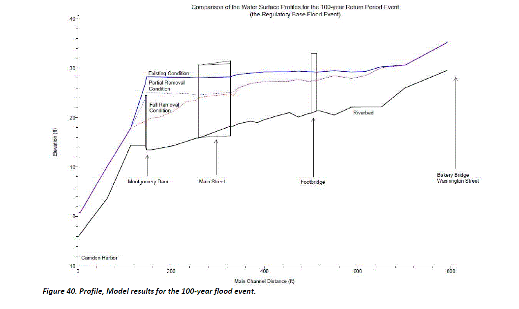
The image above illustrates the flood risk the Montgomery Dam poses to Main Street Camden during a 100-year flood event.
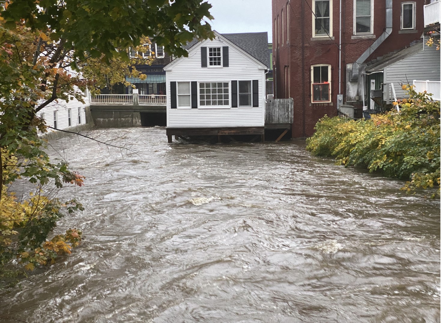
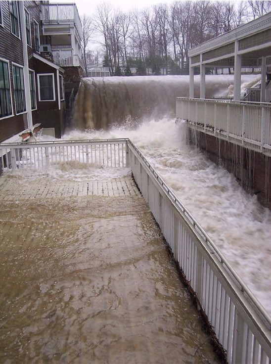
This image is of high water during a normal Spring rain event upstream from the Main Street bridge:
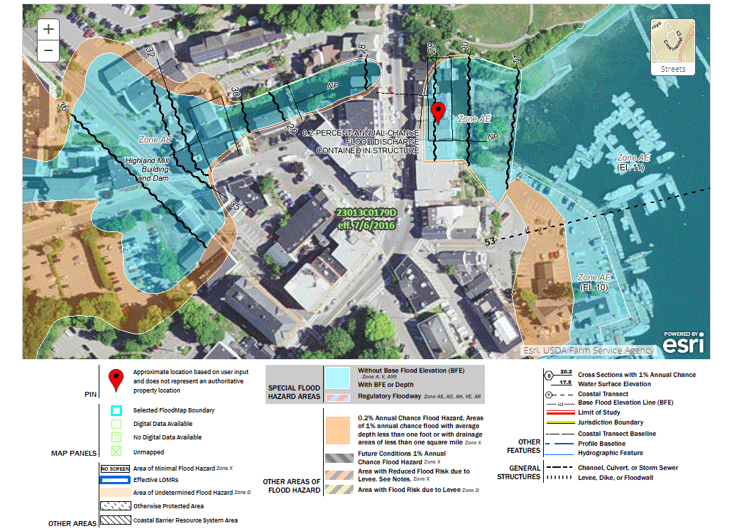
This image illustrates the flood plain as identified by FEMA:
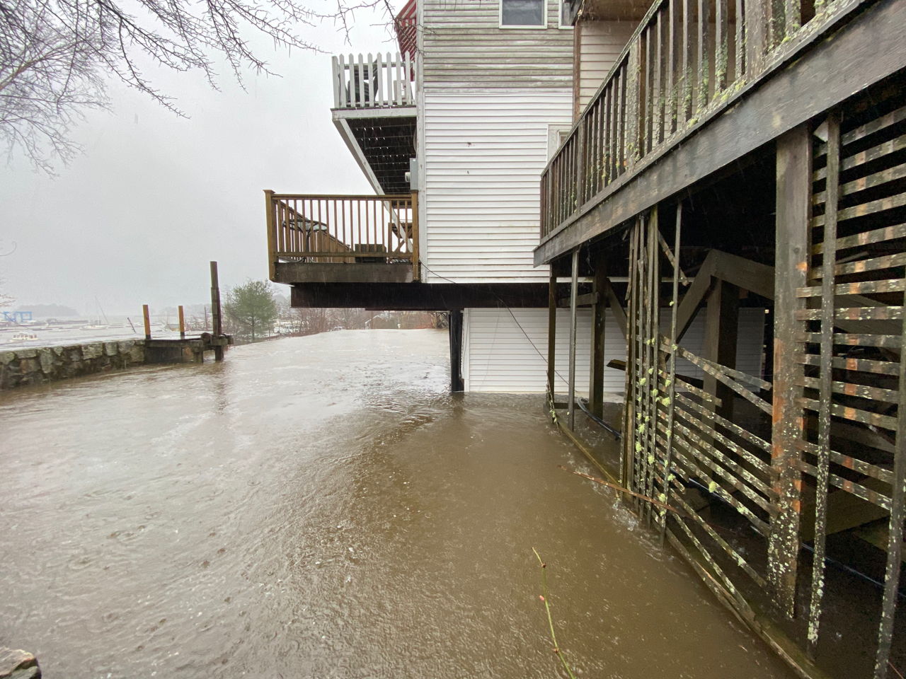
Flooding behind the Montgomery Dam during a heavy rain event

High tide flooding in Harbor Park
Knox Mill flooding during Spring rain event in 2005
Q2: Why does the Town open and close the gate on the Montgomery Dam?
A2: On a daily basis the Town’s Dam Control Agent inspects the dam to determine if the gate should be opened for flood control purposes, or for private property owners to do building maintenance, or closed for aesthetic purposes. Two people are required for opening/closing the gate. Opening the gate during rain and melt events prevents the dam’s impoundment from filling up and flooding the buildings that surround the impoundment. This level of constant management and flood mitigation would not be required if the dam were removed because the dam creates the flood risk by impounding water that would otherwise flow into the Harbor. The constant need to open and close the gate also consumes a significant amount of Town staff time and the constant need to balance competing interests.
Q3: Why is the Town is currently only designing an option where the Montgomery Dam is removed and the natural river channel is restored?
A3: The Town received a Coastal Communities grant to design and engineer an option that restores coastal habitat and reduces impacts from climate change, such as flooding due to increased/more intense rain events, as per the requirements of the grant. Any option that preserves the dam does not reduce the risk of flood due to increased rain events caused by climate change. Because this does not fulfil the requirements of this grant, any option that entails preserving the dam must be funded by Camden property tax payers. Therefore, while the Select Board and community may decide to consider an option that does not entail dam removal, it must be pursued separately from this particular project, with the understanding that the flood risks from more frequent and intense rain events will persist.
Q4: Why is the Town not designing an option that entails keeping the dam and installing a fish ladder?
A4: Any option that preserves the dam does not fulfil the goal of reducing flood risks, reducing long term maintenance costs, or reducing staff time associated with the constant monitoring and opening/closing of the Dam’s gate. Reducing flood risks is the primary interest of State and Federal funding partners. In addition, a fish ladder creates another piece of infrastructure that is incredibly costly to build and will be expensive and labor intensive to maintain on a long-term basis.
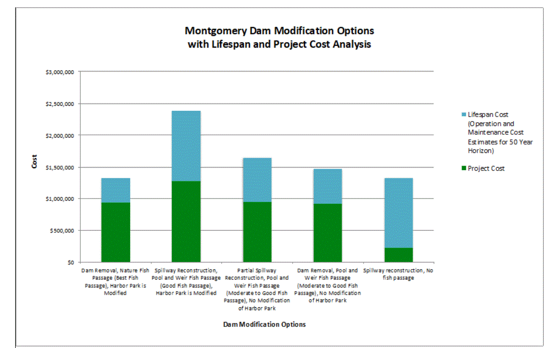
Q5: Will removing the Montgomery Dam and creating fish passage be expensive?
A5: Removing the Montgomery Dam and creating a fish passage solution is the option that will result in the least long-term costs for Camden taxpayers as per the chart below. In addition, pursing an option that results in the restoration of the river to as close to a natural state as possible, has the highest likelihood of receiving grant funding.
Q6: What is the Town also including the Harbor Park sea wall in the project to remove the Montgomery Dam and restore the natural river channel? What is the connection between the two?
A6: Initially it was hoped the dam and sea wall could be treated separately and that the sea wall was in good enough condition to last in its current form, but it has become clear that is not the case. Since the dam and the sea wall are connected, it is necessary that they are addressed holistically.
Q7: Does the Montgomery Dam impact water levels on Megunticook Lake?
A7: The Montgomery Dam has no impact on water levels at Megunticook Lake. Only the East and the West Dams impact lake levels. The Montgomery Dam only impacts water levels within its impoundment which goes from the structure itself (at the mouth of the river) to 25 Mechanic Street.
Q8: Are the aesthetics of the area being considered when looking at designs that entail removing the dam?
A8: In addition to working with Engineers, the Town is also working with a Landscape Architect on design options to maintain the beauty of Harbor Park and where the river enters the Harbor, as well as improving the aesthetics of the area where the dam impoundment is currently located. The drawings below illustrate a number of concepts for how the appearance of the buildings around the impoundment could be improved if they become visible in the event the dam is removed.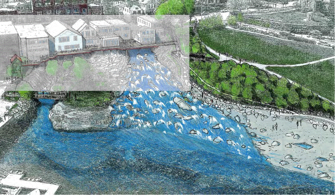
For more information about the flooding risks of increased and more intense rain events please read this article on the impacts of Hurricane Irene in Vermont.
Additional Resources:
| Video about work on the Sheepscot River with Midcoast Conservancy |
Magic on the River |
| Video about the history of Camden's dams made by Alison McKellar | Megunticook River Restoration Project |
Website created by Watershed School students about restoration of the river and climate change connections |
Reviving the Megunticook |
State Climate Change Summary from NOAA: https://statesummaries.ncics.org/chapter/me/